Territory and peace in rural areas: spatial organization in Agua Bonita II village (Caquetá, Colombia)
Stefani Castaño Torres1
Luis Carlos Ardila Burbano2
Yeimy Natalia Valderrama Polania3
Cómo citar este artículo / To reference this article / Para citar este artigo: Castaño-Torres, S., Ardila-Burbano, L.C. y Valderrama-Polania, Y. N. (2026). Territory and peace in rural áreas: spatial organization in Agua Bonita II (Caquetá, Colombia). Revista UNIMAR, 44(1), e4741. https://doi.org/10.31948/ru.v44i1.4741
Reception date: March 27, 2025
Review date: July 3, 2025
Approval date: October 28, 2025
Abstract
The particularities of the collective reintegration process of the Fuerzas Armadas Revolucionarias de Colombia (FARC) have facilitated the territorial configuration of former combatants. This article examines the territoriality and spatial organization in Agua Bonita II village (Caquetá, Colombia). The analysis is developed from a qualitative perspective, utilizing tours of the village, interviews, life stories, and, complementarily, questionnaires were used as techniques for generating information. The results allow for an analysis of territoriality on three levels: private, economic, and social infrastructure. These levels enable the appropriation of territory, oriented toward the FARC community project. The article highlights the complex and contradictory convergence between forms of settlement and private and community life. None of these dynamics is fully realized in the village; however, each contributes, from its strengths, to the process of consolidating the FARC community. Likewise, from their rationalities, they present important challenges and tensions for the collective life of these rural dwellers.
Keywords: territoriality; FARC community; peace signatories; reintegration; rurality
Territorio y paz en la ruralidad: organización espacial en el poblado Agua Bonita II (Caquetá, Colombia)
Resumen
Las particularidades del proceso de reincorporación colectiva de las Fuerzas Armadas Revolucionarias de Colombia (FARC) han facilitado la configuración territorial de los excombatientes. En este artículo se examinan la territorialidad y la organización espacial del poblado Agua Bonita II (Caquetá, Colombia). El análisis se desarrolla desde una perspectiva cualitativa, en la cual los recorridos por el poblado, las entrevistas, las historias de vida y, de manera complementaria, los cuestionarios constituyeron las técnicas de generación de información. Los resultados permiten analizar la territorialidad en tres niveles: infraestructura privada, económica y social; estos niveles posibilitan la apropiación del territorio, orientada al proyecto de comunidad fariana. El artículo destaca la convergencia compleja y contradictoria entre formas de poblamiento y de vida privada y comunitaria. Ninguna de estas dinámicas se materializa completamente en la vereda; no obstante, cada una aporta, desde sus fortalezas, al proceso de consolidación de la comunidad fariana. Asimismo, desde sus racionalidades, plantean importantes retos y tensiones para la vida colectiva de estos pobladores rurales.
Palabras clave: territorialidad; comunidad fariana; firmantes de paz; reincorporación; ruralidad
Território e paz na ruralidade: organização espacial na aldeia de Agua Bonita II (Caquetá, Colômbia)
Resumo
As particularidades do processo de reintegração coletiva das Fuerzas Armadas Revolucionarias da Colombia (FARC) facilitaram a configuração territorial dos ex-combatentes. Este artigo examina a territorialidade e a organização espacial da aldeia de Agua Bonita II (Caquetá, Colômbia). A análise é desenvolvida a partir de uma perspectiva qualitativa, na qual os percursos pela aldeia, as entrevistas, as histórias de vida e, de forma complementar, os questionários constituíram as técnicas de geração de informação. Os resultados permitem analisar a territorialidade em três níveis: infraestrutura privada, económica e social; esses níveis possibilitam a apropriação do território, orientada para o projeto da comunidade fariana. O artigo destaca a convergência complexa e contraditória entre formas de povoamento e de vida privada e comunitária. Nenhuma dessas dinâmicas se materializa completamente na aldeia; no entanto, cada uma contribui, a partir de seus pontos fortes, para o processo de consolidação da comunidade fariana. Da mesma forma, a partir de suas racionalidades, elas apresentam desafios e tensões importantes para a vida coletiva desses moradores rurais.
Palavras-chave: territorialidade; comunidade fariana; signatários da paz; reintegração; ruralidade
Introduction
Changes to the built environment, resulting from human activity, are one of the manifestations of territoriality. Through these changes, people give tangible form to their economic and cultural ideals, while also making their political and social processes visible. Those who signed the peace agreement are no exception to these practices. With the signing of the 2016 peace agreement between the Colombian government and the guerrilla group Fuerzas Armadas Revolucionarias de Colombia-Ejército del pueblo (FARC-EP), the process of disarming its members began, paving the way for the implementation of a community reintegration model aimed at strengthening a sense of belonging to the territory.
Community reintegration has sought to continue the group bonds of solidarity and collective work that the FARC community had during the insurgency (Carranza, 2020). In this context, the most evident effort has been the founding of peace villages, an experience that reflects the spatial materialization of this model. The origins of these spaces date back to point 3 of the peace agreements, which established the creation of 19 transitional rural normalization zones (ZVTN) and 7 transitional normalization points (PTN). These spaces were conceived as temporary for the weapons handover process and were established to last six months. However, in practice, this duration was extended by an additional three months (Decree 1274 of 2017).
In 2017, these sites were legally transformed into Territorial Areas for Training and Reintegration (ETCR). Their new objective was to facilitate the adaptation and return of former combatants to civilian life (Decree 2026 of 2017). Although the ETCRs were presented as temporary, they began to reinforce the territoriality and permanence of the signatories in the area.
Amid multiple interests and differing territorial agendas, the legal termination of the ETCs was established in 2019; the national government invited local administrations to recognize them in their territorial planning. In each zone, the territorial dynamics have been different. However, 24 of the former ETCRs (AETCRs) remain recognized by the State today. This is the result of the social and community processes of the signatories, their families, and neighboring communities.
This particular aspect of the reintegration process has led to the development of various analyses that seek to characterize these reintegration experiences from a territorial perspective (Narváez and Perafán, 2022; Méndez, 2022; Peralta and Sánchez, 2022; Rodríguez, 2023; Muñoz, 2023; Oviedo and Pungo, 2024). These approaches have highlighted how former combatants’ lives facilitate the formation of new hubs of interaction (Méndez, 2022; Peralta and Sánchez, 2022; Muñoz, 2023; and Rodríguez, 2023). However, these hubs are caught between various tensions: (1) land use planning that struggles to harmonize environmental protection and rural production (Méndez, 2022; Rodríguez, 2023); (2) individualization as a trend in civil life that weakens FARC cohesion and identity (Rodríguez, 2023), and (3) ghettoization, embedded in the state’s conception of reintegration, which fosters logics of integration-exclusion (Peralta and Sánchez, 2022).
These tensions affect the sense of place among people in the process of reintegration. In some cases, they manifest as a lack of roots and identity with the territory, leading to displacement outside the AETCRs (Muñoz, 2023). In others, by contrast, territoriality is constructed from the legacy of FARC identity (Méndez, 2022; Oviedo and Pungo, 2024). This identity is proudly asserted and expressed as a sense of social and political commitment, which prioritizes community belonging and ties to the collective of former combatants, as well as collective ownership and work (Oviedo and Pungo, 2024).
This situation is no stranger to Caquetá, a department that has been central both in the fight against insurgency and drug trafficking and in the search for peace agreements. Currently, the department is home to two of the 24 AETCRs nationwide and is the place of residence for 6.07% of the signatories (Agency for Reintegration and Normalization [ARN], 2024). Although only 1,899 former combatants live in the AETCRs (ARN, 2024), their efforts have made it possible for these territories to endure over time and be formally incorporated into the land-use planning system. Therefore, intending to highlight their experiences and practices of peacebuilding, this research seeks to analyze the construction of territory and rural territoriality by the FARC community in the Agua Bonita II AETCR. This settlement is located in the Agua Bonita II village of the municipality of La Montañita.
Most of the residents who arrived at this AETCR were signatories from the 3rd, 14th, and 15th fronts of the FARC-EP. Currently, the settlement is home to approximately 200 people, including women, men, boys, and girls. Not all of its residents belonged to the ranks of the dissolved guerrilla group, as the settlement is also home to relatives of signatories, farmers, and transient workers in the area.
This is a setting of interest for research, given the commitment and influence that its inhabitants have had in the region. Their continued presence has sought to uphold their ideals of struggle, centered on working the land, sustainability, and the promotion of values such as wholeness, responsibility, camaraderie, criticism, and self-criticism (Biblioteca Popular Alfonso Cano, 2022). These issues are considered in this article to constitute the FARC identity. This identity reflects a perspective on community work that combines the practices learned in the FARC-EP with those of the peasantry: «We are from the countryside, and we must live in the countryside, because the countryside is life» (Biblioteca Popular Alfonso Cano, 2022, p. 101).
Territory and Territoriality: Theoretical Approaches to Understanding Spatial Transformations.
In the academic sphere, there are various ways of conceiving of territory. These approaches primarily define territory based on people’s daily lives. In this sense, territory is in a state of constant transformation, and its conception is shaped by the economic, political, social, and philosophical interests of its actors. According to Rincón (2012), «the proposed concepts of territory depend in their formulation on various variables: worldview, interests, and position regarding power relations, as well as the philosophical stance and values of those who construct them» (p. 119), an issue to which Saquet (2015) adds the material and heritage dimensions, which, together, allow for the development of the geographical indication as a tool for local development (Saquet, 2016).
«Territory is socially constructed, organized, and planned, with concrete meanings for people in their places of life» (Quaini, as cited in Saquet, 2015, p. 56), which highlights the material dimension of territory, in which social relations and representations become tangible: «Nothing is conceived, done, or transformed without passing through the materiality of places» (Dematteis, 1999, as cited in Saquet, 2015, p. 52). The materiality of the territory is related to its philosophical and subjective dimensions; social processes converge within the territory, that is, between people and with the environment. The territory reflects processes of appropriation through the construction of sentimental values, identity, and well-being for its inhabitants.
Regarding the variable of power relations, for Samper (2021), territories fully constitute processes of rational governance, negotiation, and consensus-building among social, private, and institutional actors. This leads to the construction of a consensual vision for the future, sustained by collective actions that bring it to fruition. This highlights that all actions carried out in a space construct territory through social relations that convey the idea of sovereignty, ownership, and enclosure. This concept allows us to identify individual or group control as a relevant dimension.
The exercise of power in the territorial approach manifests itself through a dialectical relationship between social architecture and spatial architecture (Claval, as cited in Saquet, 2015). The former, manifested in the relational framework of power, results in the materialization of institutions such as the state and the social and political organizations of a community. The latter refers to materializations that organize, design, and transform space. Spatial architecture is made possible through the relational framework of power. Similarly, «space intervenes in society and supports life and activities» (Saquet, 2015, p. 31). In line with the dimension of power underlying the territory, it can be asserted that the territory constitutes the materialization of the interests of the actors involved in it, a process that is reinforced and reproduced through spatial architecture.
Accordingly, ex-combatants «begin to generate changes in public space and turn “the space” into “their space”, since part of feeling part of a place is appropriating it» (Rodríguez, 2023, p. 149). These spatial transformations are most visible in the collective reintegration4 model. This model is territorialized in the AETCRs, a space where practices associated with the reproduction of life, economic production, and circulation converge. These last two aspects are highlighted by Saquet (2015) as part of land uses.
For Saquet (2015), «Work lies at the foundation of the construction, deconstruction, and reconstruction of habitat and territory through the production of concrete objects (materializations) and symbols (economic, political, and cultural), such as language» (p. 32). The relevance of labor in territorial configuration is closely related to the social and economic interventions considered in the process of reincorporation. These interventions, as they take place in primarily rural settings, begin to reveal the interdependence and complementarity between the countryside and the city, an issue that Gottmann (as cited in Saquet, 2015) refers to as circulation. For Saquet, circulation facilitates the territory being «used and transformed into the CMP (capitalist mode of production), a process centered on the concentration of capital» (p. 62), an issue that would pose significant challenges to rural territorialities.
According to Saquet (2015, following Damatteis), rural territorialities coexist with the fast pace of industry and the market. «There are inequalities and differences, varying levels of growth, development, production, marketing, market integration, mechanization, political organization, cultural formation, etc.» (p. 102). The author likens rurality to slow rhythms, family relationships, and ties of neighborliness and community; it is always at a disadvantage compared to the speed of transformation at the urban level. Rural territorialities would then be “the result of the economic, political, and cultural actions of specific actors, distinct from urban life, and can be understood as a condition of life that is not disconnected from the urban” (Medeiros, as cited in Saquet, 2017, p. 43).
This definition of rurality highlights the multiscalar nature of territory. That is, «territory can be understood at different levels of the geographical scale: local, regional, national, plurinational, global» (Giménez, 2001, p. 7). Rural territorialities would be primarily local and would be deeply influenced by social, political, and market transformations at other scales of analysis. Accordingly, the transformations experienced in the world’s agricultural sectors toward the corporate agricultural system (Van Der Ploeg, 2011) have brought about significant changes in rurality. According to Bengoa (2003):
Rural communities must no longer merely “know how to do,” but also “know how to say”—that is, explain their own identity in comprehensible terms. Their survival depends not only on the economy, but primarily on culture, even when they are in economically marginal spaces. They depend on the meaning that human beings ascribe to that activity, which is established in relation to the rest of society. (p. 95)
This observation highlights the dimension of meaning associated with territory, which allows us to speak of territoriality. According to Montañez and Delgado (1998), «territoriality is associated with appropriation, and this with identity and spatial affectivity, which combine to define territories appropriated by right, in fact, and affectively» (p. 124). In this sense, rural territorialities are no longer characterized solely by small-scale agricultural production for the local market (Mançano, 2012). They must also give rise to peasant identity, that is, «their own cultural system, symbols, values, and deepest aspirations» (Gimenez, 2001, p. 12).
The call for the recovery of peasant identity is interpreted by Saquet (2016) as a potential for geographical indication in rural territorial development. For this author, geographical indication is a tool that allows for the promotion and protection of products typical of a territory. These products may include knowledge, techniques, and images, but also signs and symbols that assert territorial heritage. Although this refers to a primarily institutional process, it allows for connecting the natural, cultural, and social characteristics of a place with the supply of goods and services within a territory (Saquet, 2016). The geographical indication strengthens the territory’s connection to broader markets and local networks, but primarily reinforces territorial identity.
Rural territorialities are, above all, place-based identities. Escobar (2010), referring to communities in the Colombian Pacific, highlights that affiliation with the river was what predominated locally: «people who live along a certain river consider themselves a community» (West, as cited in Escobar, 2010, p. 64). In these communities, the connection to the river was the most important factor in defining who they were, as living in riverside areas identifies people as a community. According to the author:
For at least a millennium, indigenous communities inhabited the territory through unique ways of engaging with the environment—the flora, fauna, rivers, sea, and the use of gold and platinum—practicing, until recent decades, a subsistence lifestyle suited to the rainforest, without the domestication of animals or meaningful sedentarization. (p. 60)
Cano (2005) refers to these territories as riverside settlements. They consist of a settlement pattern in which the river, as a subsistence resource, is the primary element. The territory is configured around dwellings aligned facing the river, to have direct access to the water and the resources it provides (Mosquera, 1992, as cited in Cano, 2015). Riverside settlements can consist of scattered dwellings, hamlets, or villages. The latter two feature rows of houses near the riverbank; they differ from one another in the degree of planning evident (Gómez, 1997, as cited in Cano, 2015). This form of spatial distribution differs from the urban grid, which is inspired «by the Roman grid plan used to build geometric cities» (Sennett, 1994/1997, p. 285). This distribution allowed for the regular organization of space and the placement of the government and relevant institutions at the center of the territory. This form of spatial organization is recalled by Bengoa (2003) as a vestige of rural territories, primarily settlements of colonial origin.
This overview allows us to affirm that «territory and territoriality are a binomial that, when separated, would yield a fragmented perception of reality and of social dynamics and conflicts» (Rincón, 2012, p. 125). It is not only a delimited space, traversed by power dynamics, but also the place where various social, political, economic, and cultural interactions unfold and are constructed. These interactions highlight the symbolism constructed by the actors who inhabit it, allowing it to become a place of permanence and appropriation. Constructing rural territory and territoriality would thus account for the particular ways in which rural communities organize, appropriate, and value local places where natural resources, agriculture, and collective identity underpin their logic of community life.
Metodology
This document is the result of the research project Territoriality, gender, and citizenship in the reintegration process of female ex-combatants: The Case of the ETCRs Agua Bonita, Caquetá. This study was conducted from a qualitative research perspective, with an emphasis on the participation of stakeholders connected to the territory. Accordingly, an ‘insider’s perspective´ was sought in order to capture the uniqueness and specific characteristics of social processes (Galeano, 2004).
The participatory emphasis of the research was linked to a notion of the subject as a constructor and producer of their own reality (Zemelman, 2004), since, through social practices and relationships, they materialize their interests and intentions. Consequently, dialogic and interactive techniques were used to gather information in an emergent, flexible, and contextualized manner (Vasilachis, 2006), to reveal the solidarities, tensions, contradictions, and disputes inherent to territorialities.
The techniques and materials used to gather information included field trips, tours, interviews, questionnaires, and community workshops. Regarding the field trips, four visits were made to the village of Héctor Ramírez, each lasting a total of three days in the territory; these took place between August 12 and November 17, 2022. Initially, a guided tour of the village was conducted on August 12, 2022, during which the first exploration of the study area took place through observation and dialogue with the residents.
During the fieldwork period, 35 interviews were conducted with various internal and external stakeholders in the town. This information was processed and coded for analysis across different categories. Additionally, 19 door-to-door surveys were conducted to broaden the scope of the characterization of the residents. These questionnaires were administered on September 16, 2022. Finally, community workshops were held with the various population groups living in the area. They included gardening activities, mapping, photography, and screen-printing workshops as part of the fieldwork; these workshops focused on various themes, such as education, peace, and territorial organization, among others.
For both qualitative techniques and quantitative questionnaires, sampling was intentional and snowball-based. A reference from one informant to another resident of the village facilitated the administration of the questionnaires and workshops. Subsequently, informants identified as key in the initial approaches were interviewed.
The data was analyzed in Atlas.ti, version 7.0, using codes such as territorial appropriation, internal and external actors, and community processes. Based on this analysis, the territorial data were structured according to their spatial scale and social uses.
Results
Agua Bonita is located in a property of the Multioctave Cooperative for the Good Living and the Peace in Caquetá (COMBUVIPAC). This organization has many signalers that arrived in 2007. Initially, the site where ex-community FARC people arrived was rented by the State, who offered to the people that became to the peace process.
For the transformation moment of the TRNZ to ETCR, the government tried to acquire all the locations at a national level. However, for this case, the owner’s access to sell directly to the signatory people who were associated with the COMBUVIPAC. In this way, the collective belonging of the land was established as a first element of appropriation that highlighted a signal of the rural life to the communal being.
This was the land of a father […] He lent it to the State to make this population, but, after some days, we started to work, and he watched how we worked. […] The father is interested in the process and said, “I do not sell this to the State, I sell you”. He left at a low price and then with the work of all. With the cooperative, we paid for it. (Interview N1, personal communication, June 18, 2018).
The selection of the land where the Héctor Ramírez peace settlement is currently located was a task carried out primarily by leaders of the now-defunct guerrilla group (Biblioteca Popular Alfonso Cano, 2022). They were looking for a place to put down roots; therefore, among their criteria, they considered that the land should be arable and that they should be able to build their homes and develop their productive activities there. This intention to settle down and build a territory became evident in the socio-community programs that were simultaneously implemented at the Biblioteca Popular Alfonso Cano. In this space, built by the community itself, various activities are carried out under the following principle: «The countryside is life», which signals a commitment to rural territoriality.
This was sought out more by us—the leaders of the space—than by the government, because the government isn’t interested in people’s well-being. We’re looking for well-being, a future, and a place to settle down—in other words, we weren’t here just to stay for two days and then say goodbye. (Tour of the town center, personal communication, August 12, 2022)
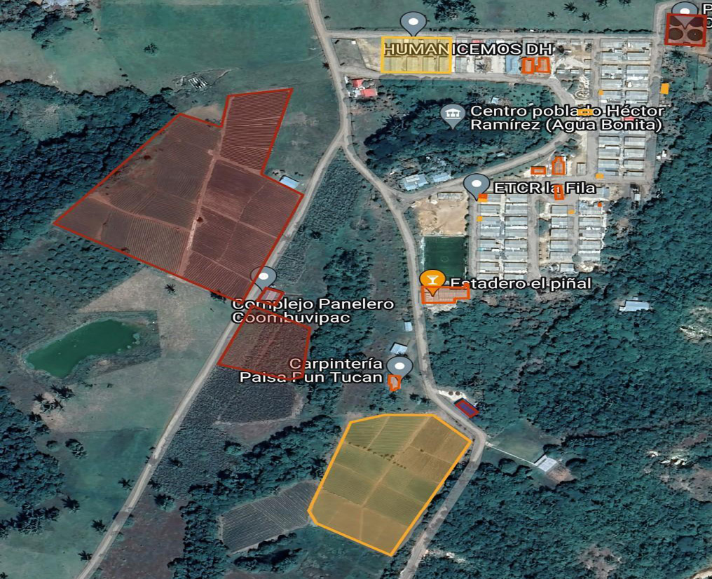
As a form of modern territorial representation (Raffestin, 2011), it is noteworthy that the residents have built a series of hedges or walls that serve to divide the space on both small and large scales. On a small scale, the town center can be divided into private spaces such as homes, and on a large scale, the division occurs in the private, economic, and social uses of the different spaces (see Figure 1).
Figure 1
Map of the Agua Bonita II settlement
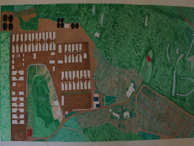
Note. A tour of the town center. Photograph taken on August 12, 2022.
Private infrastructure, tensions with community life
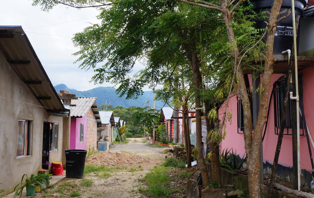
In Agua Bonita II, the settlement pattern follows an urban grid, in contrast to the riverside pattern that characterized guerrilla life. The settlement has 55 residences or modules, clustered in the center. Its physical infrastructure replicates the logic of a ‘labyrinth of streets’ (Sennett, 1997), which facilitates automobile traffic and connects the different parts of the territory.
Thus, the unit of construction (Sennett, 1997) in Agua Bonita II is the city block, which, as a legacy of medieval urbanization, «consists of rows of individual houses along the street» (Sennett, 1997, p. 356). This form of settlement contrasts with the encampment-based lifestyle that characterized the FARC-EP community when they were armed. The dynamics of armed conflict forced them to establish temporary camps near rivers, where social spaces, as well as areas for food and sanitation, were communal. The camps of the armed FARC-EP are not strictly settlements; however, they retain a logic of spatial occupation similar to that of riverside settlements, which fosters community life.
This logic is not preserved when the settlement is built. Because it is an area without adequate infrastructure, the signatories initially constructed a small-scale physical representation of the types of spaces they envisioned having there. From the very design of the settlement, there was a distinction between common and private spaces.
The initial priority was the construction of the so-called modules, which would house the signatories who arrived at the site at the time of the weapons handover. Later, these modules began to be modified to serve as private spaces. Their allocation was contingent on the decision to continue the reintegration process as a community, through their affiliation with COMBUVIPAC.
Currently, these modules constitute the housing of Agua Bonita II, where the signatories, their families, and those who have come to live in the area reside. Each resident has built a home on their plot. Most of them have porches and front yards, areas that could be considered rural social spaces. It is also common to see them growing aromatic plants, tomatoes, onions, cassava, and other crops for daily consumption. These practices reflect the preservation of rural customs associated with subsistence farming.
Homes with fewer amenities have at least one room, although most have two or three, bathrooms, and even commercial spaces, as well as spacious communal areas such as the kitchen and living room, plus one or two entrances from the street. These layouts reflect the importance of community life, even within the signatories’ private spaces (see Figures 2 and 3).
Figure 2
Homes in the village

Note. A tour of the town center. Photograph taken on August 12, 2022.
Figure 3
Homes in the village
Note. A tour of the town center. Photograph taken on August 12, 2022.
Currently, there are almost no homes made of Superboard in the town center, since this material has a lifespan of 2 to 3 years without any maintenance. For this reason, several residents have replaced it with other materials such as brick and wood. The homes have been modified according to the residents’ financial resources and their dedication to improving their living spaces. Homes are shared with relatives who have arrived, as well as other people who come sporadically, as person B2 explained:
Well, everyone has their own little house. Initially, 60 modules were installed here [...], but now there’s practically nothing left from the government, because everything that was provided was made of Superboard. People have been transforming their own homes into brick structures with their own designs, based on their own ideas, because, well, it’s been five years now—this is ours, and let the government continue with its own process. (Tour of the town center, B2, personal communication, August 12, 2022)
The houses have been built or are currently being built, depending on each family’s needs. Some of the homes have businesses or various individual economic initiatives, which serve as a means of subsistence to ensure a basic standard of living for their members. Each house reflects the effort and dedication its inhabitants have put into remodeling what was once a prefabricated unit, which did not allow them to have a permanent family space, as German mentions:
Yes, it’s called Superboard; I knocked down and redesigned it differently because it was just some beams like that, without much aesthetic appeal, without much craftsmanship […], the floor is tiled, and here it has all the utilities: electricity, internet, trash, gas, and television. (GB3, personal communication, September 15, 2022).
Each of the homes has something unique, whether it’s gardens or the color of the facade. The latter has been the main mechanism for affirming the town’s FARC identity. Since November 2017, its residents have been holding the annual Agua Bonita se pinta de colores con manos de paz y reconciliación Festival. This event consists of a week of large-scale activities during which muralists from different places are invited to create murals on the facades of the homes. The murals aim to recover FARC memory, reaffirm the commitment to peace, and promote reconciliation. In this way, the town becomes an open-air gallery of memory.
This is one of the cultural and community initiatives undertaken by the signatories to promote peace, memory, and reconciliation. At the same time, it serves as a geographical marker that highlights the territoriality of the signatories. In this context, Agua Bonita presents itself as a territory marked by cultural practices that promote FARC identity and memory. This is because a significant portion of the images on the murals allude to prominent figures from the now-defunct guerrilla group or champion values and political commitments that existed during the armed struggle. Thus, the following account highlights what the festival means to the town’s community:
A long time ago, almost six years now, we began a dream called Agua Bonita se pinta de colores. This year marks the fifth edition, and we’ve kept that dream alive. It started in 2017 with a few white houses. This year, this is our vision, this is our dream in which we’ve turned art into a tool for transformation. This is Agua Bonita. (Discussion Series: Contributions to Art and Culture, Agua Bonita se Pinta de Color Festival, personal communication, November 2022)
The festival has evolved over the years, becoming a «hallmark of the region», as recent editions have expanded to include mural-painting workshops outside the village, while also seeking to raise its profile, foster reconciliation with other regions, and promote Agua Bonita’s cultural heritage as an opportunity for local development (see Figures 4 and 5).
Figure 4
Murals created at the Agua Bonita se Pinta de Colores Festival
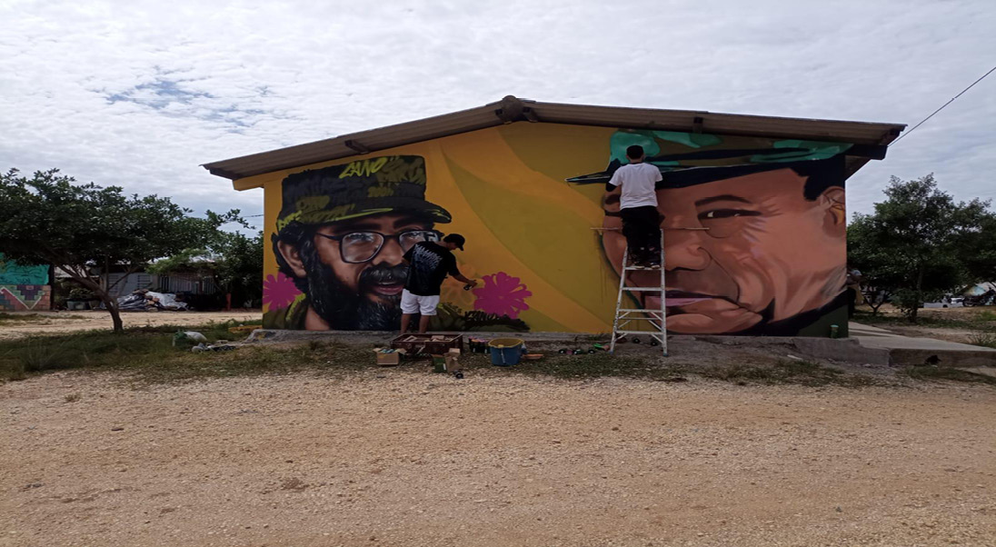 Note. A tour of the town center. Photograph taken on August 12, 2022.
Figure 5
Murals created at the Agua Bonita se Pinta de Colores Festival

Note. A tour of the town center. Photograph taken on August 12, 2022.
Unexpectedly, Agua Bonita II is not immune to the individualistic rationality underlying the grid layout. As Sennett (1997) notes, the urban grid ultimately fosters patterns of detachment from the community. The fact that each person lives in more enclosed spaces points to a society that prioritizes privacy and comfort through individual autonomy. This is an issue that causes tensions and criticism among the town’s residents.
Back in the guerrilla days, you’d keep an eye on the peer sleeping next to you, and if he didn’t wake up, if he didn’t get up, you’d go… here it’s very difficult. For example, the peer or neighbor who lives over there on the corner, and I live here: how am I supposed to know if he woke up or didn’t wake up? Or if he got up or didn’t get up? Here, most people stay locked up; you walk by and see all the houses… You don’t know if there are people inside or not […], a lot has been lost, like collective work—it’s been lost—because when we first arrived here, we worked collectively and everyone would go out. [...] So I think this has been lost because here we no longer live only with reintegrated people, but some people were never in the ranks; so that also makes reintegration difficult, because we [FARC] have certain principles and values that we still apply, and many people who come from outside—they don’t really care, I mean, they care very little about the collective. (Interview 2Y, personal communication, May 30, 2024)
In this way, the private spaces of Agua Bonita are appropriated amid the tension between private and communal life. Private appropriation highlights the rural territoriality of the ex-combatants, oriented toward subsistence agriculture and shaped by the family needs and interests that have taken form over the years of reintegration (see Figure 6). Community appropriation is evident through the recovery of memory and FARC-related claims. These tensions, though oscillating between individualism and collectivism, demonstrate that territoriality is not always constructed as a coherent continuum between the individual and collective meanings past and present assigned to the territory.
Figure 6
Map of the private infrastructure
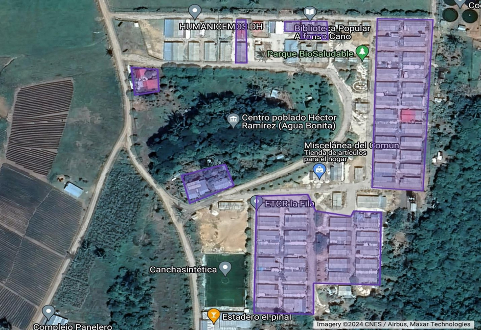
Note. Created using satellite imagery from Google Maps, 2024.
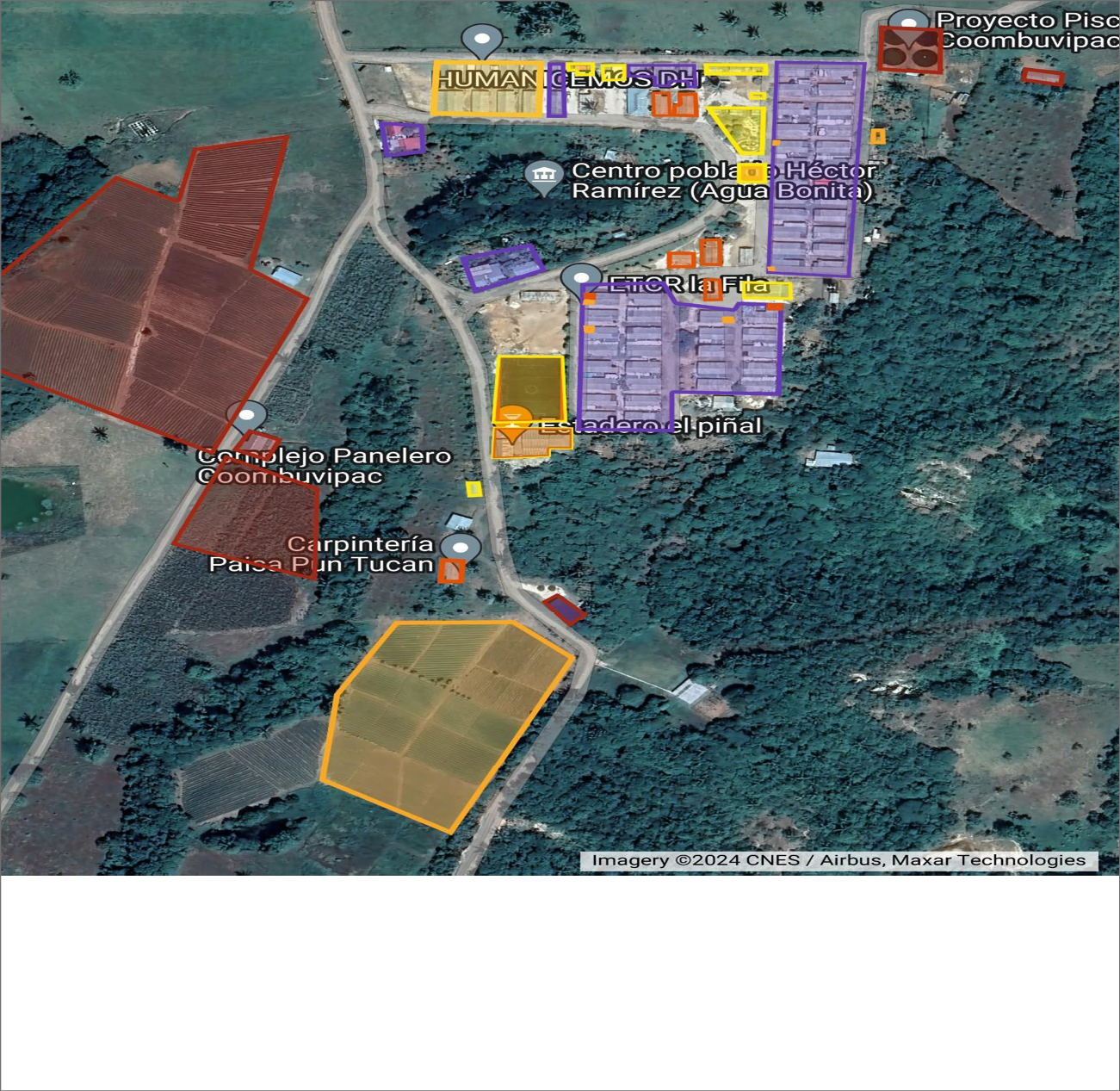
Economic infrastructure, connections between the FARC identity, the peasant identity and cooperativism
According to Carranza (2020), in reintegration processes, «providing financial assistance or creating income opportunities has been seen as a way to prevent recidivism» (p. 211). For this reason, the development of economic initiatives has been central not only for the national government but also for the FARC community itself. Hence, as a collective, they have designated specific areas of the territory for the development of productive projects. This infrastructure ensures the sustainability of the settlement by stimulating economic and labor activities and generating income for its inhabitants.
The space housing the tailor shop and the shoe repair shop was built so that the signatories involved in this line of production could carry out the project under suitable conditions. Over time, these projects operated sporadically, as low demand for the products meant they could only be made to order. Consequently, the space is also used as a small warehouse where other production machinery is stored.
The projects that have facilitated the development of economic infrastructure are, for the most part, driven by COMBUVIPAC. Each productive project has an assigned space and infrastructure designated for its implementation. These projects are characterized by their community-based nature; very few are individual initiatives. The economic infrastructure of the village thus adheres to the principles of cooperative organization, in which its «non-profit» status (Law 454 of 1998) is oriented toward a proportional distribution of surpluses both among members and for reinvestment in the organization, thereby promoting the economic development of the territory. This ensures the availability of certain means of production to strengthen territoriality and the peasant production system based on «diversity, small-scale operations, and the local market» (Mançano, 2012, p. 10).
Likewise, there is land set aside for pineapple crops, which is developed as both a community and an individual project. This generates employment and occupies a large portion of the village’s land.
Here, the money they earned was invested in productive projects. The first productive project they set up was the pineapple, which many people thought was crazy [...], because today that project, I’m not saying it is the best, but it’s a project that’s been going on for 5 years now. There’s the one at the entrance and the one here [points to the location of the crops]. (Tour and conversation – ARN, personal communication, August 13, 2022)
‘El Piñal’ is one of the iconic places in Agua Bonita II. The name of the roadside is because of its location near the pineapple fields, in a new effort to establish a geographical marker associated with the village. This is also a space for economic and social development. There, beverages and spirits are sold, in addition to recreational services such as a nightclub and pool. This space is also used for large-scale community activities, making it a venue for exchange between actors both within and outside the town. This dual purpose of the space demonstrates the continuity of FARC principles, practices, and values, since, as stated in the Biblioteca Popular Alfonso Cano (2022):
Comradeship is one of the fundamental principles in our community. It is one of those concepts we must cherish most carefully because it is where we all saw one another as if we were a single family, with affection among all people. When we speak of this, we are speaking of a very deep friendship; we are speaking of fraternity, camaraderie, solidarity, and harmony. (p. 101).
There is also an economic infrastructure supported by projects funded with the personal resources of the signatories. Examples include woodworking, pig farms, passion fruit cultivation, Sacha Inchi cultivation, soursop cultivation, home gardens, shops, food stalls, and one of the pineapple farms. For the most part, this infrastructure is associated with agricultural activities, reflecting once again the FARC community’s commitment to peasant farming. «We are FARC people, but we are also peasants; we come from the countryside, and we are devoted to the countryside» (Biblioteca Popular Alfonso Cano, 2022, p. 101), a statement that highlights peasant labor as the foundation of FARC territorial development.
Likewise, gender-focused initiatives have left their mark on the territory. The Association of Women Producers of Esencias de Paz (ASMUPROPAZ) has a laboratory located in areas near Agua Bonita II, where medicinal plants are processed to extract oils and beauty products. These products are sold at La Comunera, a shop in the village dedicated to selling products created by the women’s initiative.
As a preliminary step toward processing raw materials, Agua Bonita II is home to a fruit pulping machine and a sugarcane mill. This preliminary industrial infrastructure adds value to the village’s agricultural production. However, it has been used primarily to ensure a continuous food supply for the area’s inhabitants, as a strategy for food sovereignty or self-sufficiency, a principle they also refer to as FARC people (Biblioteca Popular Alfonso Cano, 2022). This infrastructure, along with fish and poultry farming projects, has been financially and educationally supported by actors and institutions outside the territory, highlighting the presence of economic circulation and production practices associated with land use.
As part of the agency and independent efforts of the population in the process of resettlement, the town’s inhabitants have succeeded in establishing connections between FARC identity, peasant identity, and the solidarity economy. The FARC principles and values of solidarity and camaraderie are integrated with peasant and solidarity-based productive practices in the territory. The tradition of peasant production for self-consumption and the local market is not at odds with FARC values and cooperative principles. The latter, as a legal framework, has become an alternative for materializing the identity and territoriality of former combatants through their economic activities (see Figure 7).
Figure 7
Map of economic infrastructure
Note. Create using satellite imagery from Google Maps, 2024.
Social equipment, materialization of the community life
The social zones built at the beginning of the town have been the offices of the Agency of Reincorporation Nacional, the places of study, a community place, and a restaurant, El Piñal. This has an objective to simplify the process of reincorporation and to promote the link between international and national entities that support that.
Initially, the community hall was built as a space for discussion and to strengthen community work among the residents. All of this took place within the framework of the community action board, an organization that sets the village’s guidelines and addresses the community’s concerns and issues. The cooperative and the community action board of Agua Bonita II are manifestations of the social architecture that has shaped the territory; through them, the spatial architecture—or the distribution and use of the village’s spaces—is defined.
This is the case with the community hall, a space equipped with bathrooms and showers, as its initial construction was designed to provide these services collectively to the residents. Thanks to this infrastructure, the community hall is used to host outsiders who come to the space to carry out various community activities. This use was defined by the community action board as a strategy to foster circulation and strengthen exchanges with other communities. Another space built from the outset was ‘la rancha’ (as the kitchens in the FARC-EP camps were called). In this place, former combatants cooked collectively in shifts; however, with the allocation of the modules for private use, ‘la rancha’ became a restaurant. The signatories involved in this line of work have the opportunity to offer visitors a menu when it is their turn in the work cycle.
The El Piñal community center, in addition to its economic use, is also a place for recreation and social integration. Some notable activities include sports events, cockfights, and cultural exchanges. This is how B2 describes it:
There is a large house on this site; that is what we call El Piñal. That is where the bazaars and the party take place. People come, have a drink, from Saturday until dawn on Sunday; that is the big party spot. In the back, there are cockfighting pits. (Interview B2, personal communication, August 12, 2022).
These places are the primary physical embodiment of FARC community cultural values and meanings, since it is within this social infrastructure that people have the opportunity to «harmoniously develop all their capacities and skills» (Biblioteca Popular Alfonso Cano, 2022, p. 100), put into practice «duty and belonging to the organization and, therefore, act out of motivation and self-sacrifice for the common good» (p. 101), and likewise build «fraternity, camaraderie, solidarity, and harmony» (p. 101).
In Agua Bonita II, other social infrastructure projects have also been taking shape, improving the living conditions of community members. These projects have been successfully consolidated thanks to strengthened ties with international and national organizations, such as the Child Development Center (CDI), the community library, and the women’s center (see Figure 8).
Among these projects, the Alfonso Cano Public Library stands out as an academic space within the village. It has enabled the preservation of the FARC’s identity, its ideology, and the history of war and reconciliation resulting from the armed conflict. The library receives support from universities, including La Sabana, through which educational projects have been implemented.
«It is called the Alfonso Cano Library, which was built thanks to the universities and is still in operation thanks to the universities» (Social mapping, personal communication, June 19, 2018).
Map of social equipment
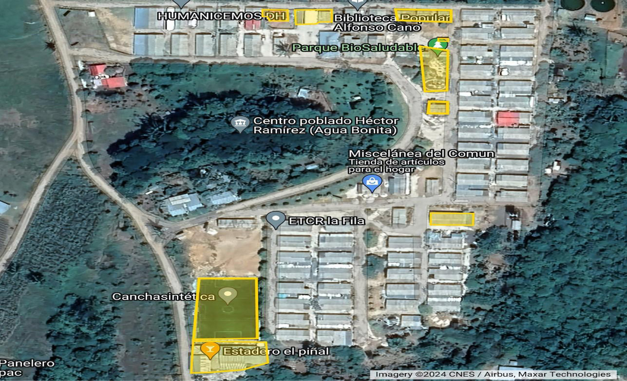
Note. Create using satellite imagery from Google Maps, 2024
Discussion
The various spatial elements analyzed in Agua Bonita II reflect the territoriality of the signatories. The legal appropriation of this territory could be considered a manifestation of rational governance (Samper, 2021). This allows them to continue their process of appropriation over time, with a clear understanding of boundaries and property in the sense of territorial control (Raffestin, 2011).
In the construction of this territory, the main source of tension is the tension between private and communal life. This has different explanations depending on the perceptions of its inhabitants: the first is associated with the rationalities implicit in the spatial organization of an urban grid or riverside settlement, which fosters individualism and private comfort. The second relates to the differentiated appropriation of FARC values and principles, in which non-reintegrated inhabitants are those who have adapted least to this philosophy of life.
Initially, highlighting different rationales among forms of rural settlement (Roman grid or riverside settlement) accounts for the territorial diversity associated with the rural world. Likewise, it highlights how, in the spatial architecture of rurality, the interests of the actors involved are also philosophical, promoting or limiting certain social values. This issue connects to the differentiation between FARC and non-FARC actors and highlights the complexities and contradictions associated with the circulation of actors and ideas in territorial processes. In conclusion, territoriality is not always constructed as a coherent continuum between the individual and collective meanings, past and present, assigned to the territory. Therefore, according to Oviedo and Pungo (2024):
The departure and disengagement of ex-combatants from the AETCRs and their related activities is not only a “physical” loss, but a loss of identity and belonging. When the ex-combatant leaves these spaces, they are left to their own devices; as long as they remain and belong to them, their experience as FARC has meaning. (p. 75).
Regarding private and economic infrastructure, the experience of Agua Bonita II contrasts with that of the AETCR Colinas, where productive initiatives focused on “teaching trades and urban production systems, without considering prior knowledge” (Bolaño-Peña and Mejía-Escalante, 2020, p. 114). In the settlement, the signatories directly propose productive projects that draw on their previous experiences, primarily as peasants. Their knowledge of the territory and the countryside is relevant to defining the activities to which they wish to dedicate themselves. Through economic infrastructure, the signatories have managed to harmonize peasant identity, FARC identity, and cooperativism, affirming work as the material and symbolic foundation of the territory (Saquet, 2015).
Finally, it is emphasized that social infrastructure best accounts for the symbolic appropriation of the territory for reincorporation, as it strengthens FARC community values and recreates a social and integrative logic (see Figure 9). These places were conceived as common spaces serving social and collective work. This infrastructure stands out as «a space of symbolic-cultural sedimentation, as an object of aesthetic-affective investment, or as a support for individual and collective identities» (Giménez, 1999, p. 29). The main result of this sedimentation is the emergence of geographical landmarks such as the Agua Bonita se Pinta de Colores Festival, an effort that reflects the valorization of the territorial heritage that the FARC community has built in this town of peace.
Figure 9
Map showing infrastructure types, Agua Bonita II settlement
Nota. Created using satellite imagery from Google Maps, 2024.
In line with Rincón’s (2012) principles, the social infrastructure in Agua Bonita II is imbued with ethical, aesthetic, symbolic, and emotional elements. The efforts to transform this community’s space «have been focused on preserving who we are, what we have become after years of war and revolutionary struggle» (Biblioteca Popular Alfonso Cano, 2022, p. 101). This reaffirms the town’s territorial identity.
Agua Bonita II possesses a great strength: the vitality of its diverse leaders, men and women who work toward the town’s economic and social development. All of this is driven by the mission to ensure that its inhabitants and future generations enjoy better living conditions. The territory is well-located, with favorable topographical and climatic conditions, as well as public services and social infrastructure that have been developed over time. Its residents have made this place their own, culturally appropriating it through symbols such as the memory of FARC, peace, and camaraderie, which reflect FARC communitarianism. This allows us to propose Agua Bonita II as a future-oriented town (Bolaño-Peña and Mejía-Escalante, 2020), which is establishing itself as an economic and cultural hub in this area of the department of Caquetá.
Conclusions
The territorial development of Agua Bonita II is marked by tensions and contradictions that, paradoxically, shape the FARC community during the reintegration process.
Tensions related to settlement patterns demonstrate that the distribution of the territory influences community dynamics.
The community commitment of the signatories of the Agua Bonita II settlement has been a central element in shaping this territory of reintegration; a commitment that draws on FARC and peasant traditions to create territories for peace and coexistence.
Conflict of interest
The authors of the article declared that they had no conflicts of interest regarding the work presented.
Ethics responsabilities
This research project was conducted in accordance with strict ethical principles. Consequently, the residents of the village of Héctor Ramírez, Agua Bonita, Caquetá (Colombia) played an active role in the project, participating in the approval and review of the various research activities carried out in that area.
Founding statements
The authors declare that they received no financial support for the development of this work
References
Agencia para la Reincorporación y la Normalización (ARN). (2024, 31 de marzo). ARN by the Numbers. https://www.reincorporacion.gov.co/es/la-reintegracion/Paginas/cifras.aspx
Bengoa, J. (2003). 25 años de estudios rurales [25 years of rural studies]. Sociologías, 5(10), 36-98. https://seer.ufrgs.br/index.php/sociologias/article/view/5426/3076
Biblioteca Popular Alfonso Cano (2022). Construyendo Comunidad. Experiencias desde la Reincorporación [Building Community: Experiences of Reincorporation]. ImagePrinting S.A.
Bolaño-Peña, M. y Mejía-Escalante, M. (2020). Reincorporación territorial para la construcción de paz. Hábitats autogestionados por excombatientes FARC-EP, Colombia [Territorial reincorporation for peacebuilding. Self-Managed habitats of former FARC-EP combatants in Colombia]. Revista Bitácora Urbano Territorial, 30(3), 109-122. https://doi.org/10.15446/bitacora.v30n3.80859
Carranza Franco, F. (2020). Arme y desarme en Colombia. Creación de ciudadanía, construcción de Estado y procesos de DDR [Arming and disarming in Colombia: The creation of citizenship, state building, and DDR processes]. Centro de Investigación y Educación Popular - Programa por la Paz.
Castaño Torres, S., Ruiz Mallungo, A. D., Gómez Díaz, A. y Yalanda Basto, I. M. (2025). Mujeres y reincorporación comunitaria: experiencias prácticas que construyen paces en el Poblado Héctor Ramírez [Women and community reincorporation: practical experiences that build peace in the Héctor Ramírez settlement]. Revista Ciencias y Humanidades, 19(1), 59-102. https://doi.org/10.61497/pkj3g293
Decreto 1274 de 2017. (2017, July 28). Presidencia de la República de Colombia. Diario Oficial 50308. https://www.alcaldiabogota.gov.co/sisjur/normas/Norma1.jsp?i=70781
Decreto 2026 de 2017. (2017, December 4). Presidencia de la República de Colombia. Por medio del cual se reglamentan los Espacios Territoriales de Capacitación y Reincorporación (ETCR), creados mediante el Decreto 1274 de 2017 y se dictan otras disposiciones. https://www.funcionpublica.gov.co/eva/gestornormativo/norma.php?i=84596
Escobar, A. (2010). Territorios de diferencia: lugar, movimientos, vida, redes [Territories of difference: place, movements, life, networks] (E. Restrepo, Trad.). Envión Editores.
Galeano Marín, M. E. (2004). Estrategias de investigación social cualitativa: el giro en la mirada [Qualitative social research strategies: the turn in perspective]. La Carreta Editores.
Giménez, G. (1999). Territorio, cultura e identidades, la región sociocultural [Territory, culture and identities, the sociocultural region] Estudios sobre las Culturas Contemporáneas Época II, 5(9), 25-57. https://economia.unam.mx/academia/inae/pdf/inae5/516.pdf
Giménez, G. (2001). Cultura, territorio y migraciones. Aproximaciones teóricas. [Culture, territory and migration. Theoretical approaches]. Alteridades, 11(22), 5-14. https://www.redalyc.org/pdf/747/74702202.pdf
Ley 454 de 1998. (1998, August 4). Congreso de Colombia. Por la cual se determina el marco conceptual que regula la economía solidaria, se transforma el Departamento Administrativo Nacional de Cooperativas en el Departamento Nacional de la Economía Solidaria, se crea la Superintendencia de la Economía Solidaria, se crea el Fondo de Garantías para las Cooperativas Financieras y de Ahorro y Crédito, se dictan normas sobre la actividad financiera de las entidades de naturaleza cooperativa y se expiden otras disposiciones. https://www.funcionpublica.gov.co/eva/gestornormativo/norma.php?i=3433
Mançano, B. (2012). Disputas territoriales entre el campesinado y la agroindustria en Brasil [Territorial disputes between peasant communities and agroindustry in Brazil]. Cuadernos del CENDES, 29(81), 1-22. https://saber.ucv.ve/ojs/index.php/rev_cc/article/view/3992
Méndez, L. A. (2022). La incorporación de los Antiguos Espacios Territoriales de Capacitación y Reincorporación- AETRC en el ordenamiento territorial y su incidencia en la construcción de paz territorial-local Caso de estudio: AETCR La Fila, Icononzo, Tolima [The Integration of the Former Territorial Training and Reincorporation Spaces (AETCR) into Territorial Planning and Its Impact on Local Peacebuilding: A Case Study of AETCR La Fila, Icononzo, Tolima] [Tesis de maestría, Pontificia Universidad Javeriana]. Repositorio institucional. http://hdl.handle.net/10554/62225
Montañez, G. y Delgado, O. (1998). Espacio, territorio y región: conceptos básicos para un proyecto nacional [Space, territory and region: basic concepts for a national project]. Cuadernos de Geografía: Revista Colombiana de Geografía, 7(1-2), 120-134. https://revistas.unal.edu.co/index.php/rcg/article/view/70838
Muñoz, D. M. (2023). Territorialidades de paz, desde la perspectiva de los y las excombatientes de las FARC-EP, ubicados en Anorí-La Plancha, Antioquia [Territorialities of peace: perspectives of FARC-EP ex-combatants in Anorí–La Plancha, Antioquia]. Memorias Forenses, (7), 99-104. https://doi.org/10.53995/25390147.1593
Narváez, K. y Perafán, G. (2022). Sentidos de territorio y comunidad por parte de mujeres firmantes del proceso de paz de los AETCR y veredas aledañas en el Caquetá. Una significación de la reintegración social (DDR) en clave comunitaria [Meanings of territory and community among women signatories of the peace process in AETCR and nearby rural communities in Caquetá. A community-based understanding of social reintegration (DDR)] [Tesis de maestría, Universidad Nacional Abierta y a Distancia]. Repositorio UNAD. https://repository.unad.edu.co/handle/10596/51633
Oviedo, E. A. y Pungo, D. A. (2024). Experiencias de la reincorporación de excombatientes de las FARC-EP en Caldono, Colombia [Experiences of reincorporation among FARC-EP ex-combatants in Caldono, Colombia]. Eirene Estudios de Paz y Conflictos, 7(12), 53-82. https://doi.org/10.62155/eirene.v7i12.229
Peralta, M. P. y Sánchez, J. (2022). Apropiación y orden espacial en los ETCR la Fila y el Oso (Tolima, Colombia) [Spatial appropriation and spatial organization in ETCR La Fila y El Oso (Tolima, Colombia)]. Investigación y Desarrollo, 30(1), 198-248. https://doi.org/10.14482/indes.30.1.303.662
Raffestin, C. (2011). Por una geografía del poder [Toward a Geography of Power] (Y. V. Velázquez, Trad.). El Colegio de Michoacán. (Original publicado 1980)
Rincón, J. (2012). Territorio, territorialidad y multiterritorialidad: aproximaciones conceptuales [Territory, territoriality and multiterritoriality: conceptual perspectives]. Aquelarre, Revista de Filosofía, Política, Arte y Cultura, (22), 119-130.
Rodríguez, J. E. (2023). Nuevos modos de habitar de excombatientes de las FARC-EP Caso de estudio: AETCR Colinas, Guaviare [New forms of living among FARC-EP ex-combatants Case Study of AETCR Colinas, Guaviare] [Tesis de maestría, Universidad Nacional de Colombia]. Repositorio Institucional UNAL. https://repositorio.unal.edu.co/items/e85ccf95-af4a-44c0-8627-ebb6ac7ea926
Samper Kutschbach, M. (2021). Artículo docente: Abordajes conceptuales del territorio en perspectiva Latinoamericana [Conceptual approaches to territory from a Latin American Perspective]. Revista Perspectivas del Desarrollo, 6(1), 72-108. https://doi.org/10.5377/rpdd.v6i1.12430
Saquet, M. A. (2015). Por una geografía de las territorialidades y las temporalidades: una concepción multidimensional orientada a la cooperación y el desarrollo territorial [Toward a geography of territorialities and temporalities: a multidimensional approach to cooperation and territorial development]. Universidad Nacional de La Plata. https://d-nb.info/1191530760/34
Saquet, M. A. (2017). Territorio, clase social y lugar: premisas fundamentales del desarrollo territorial de base local, ecológica y cultural [Territory, social class, and place: key foundations of territorial development based on local, ecological, and cultural dimensions]. Arquetipo, (15), 39-69. https://doi.org/10.31908/22159444.3675
Sennett, R. (1997). Carne y piedra, el cuerpo y la ciudad en la civilización occidental [Flesh and stone: the body and the city in western civilization]. (C. Vidal, Trad.). Alianza editorial. (Obra original publicada en 1994).
United Nations Peacekeeping. (2025). Desarme, desmovilización y reintegración [Disarmament, Demobilization, and Reintegration]. https://peacekeeping.un.org/es/disarmament-demobilization-and-reintegration
Van Der Ploeg, J. D. (2011). Prefacio. En: E. Sabourin, Sociedades e organizações camponesas: uma leitura através da reciprocidade [Preface. In E. Sabourin, Peasant Societies and Organizations: A Reading through Reciprocity] (pp. 11-14). Editora da UFRGS.
Vasilachis de Gialdino, I. (2006). Estrategias de investigación cualitativa [Strategies for qualitative research]. Gedisa.
Zambrano Quintero, L. (2019). La reincorporación colectiva de las FARC-EP: una apuesta estratégica en un entorno adverso [Collective reincorporation of the FARC-EP: a strategic commitment in an adverse environment]. Revista CIDOB d’Afers Internacionals, (21), 45-66. https://doi.org/10.24241/rcai.2019.121.1.45
Zemelman, H. (2004). En torno de la potenciación del sujeto como constructor de historia [On empowering the subject as a maker of history]. En M. C. Laverde, G. Daza y M. Zuleta (Eds.), Debates sobre el sujeto. perspectivas contemporáneas (pp. 91-104). Universidad Central-DIUN-Siglo del Hombre Editores.
Contribution
Stefani Castaño Torres: Principal investigator of the Eirênê research group. Statistical data analysis, drafting of the Materials and Methods section, and compilation of results.
Luis Carlos Ardila Burbano: Analysis and interpretation of results, drafting of the Introduction, Methods, Discussion, and Conclusions sections.
Yeimy Natalia Valderrama Polania: Analysis and interpretation of results, drafting of the Introduction, Methods, Discussion, and Conclusions sections.
Statement on the use of artificial intelligence
In writing this article, the authors did not use any artificial intelligence tools or services to draft the manuscript.
Adjunct Professor, Universidad Surcolombiana; Member of the Research Group on Educational and Social Practices, Universidad Surcolombiana, Neiva, Huila, Colombia. Email: scastanotorres@gmail.com


2 Bachelor’s student in Social Sciences, Universidad Surcolombiana; member of the Eirênê research group, affiliated with the Research Group on Educational and Social Practices, Universidad Surcolombiana, Neiva, Huila, Colombia. Email: u20201188696@usco.edu.co
3 Bachelor’s student in Social Sciences, Universidad Surcolombiana; member of the Eirênê research group, affiliated with the Educational and Social Practices Research Group at Universidad Sucolombiana, Neiva, Huila, Colombia. Email: u20201186705@usco.edu.co
4 The term reintegration is a national adaptation that refers to the third phase of the Demobilization, Disarmament, and Reintegration (DDR) process. DDR as a concept was first used by the United Nations to describe a process aimed at ensuring the transition of combatants to post-conflict or post-war settings. Reintegration—or, in the Colombian context, reincorporation—involves legal, economic, and social interventions to ensure the return of former combatants to civilian life (United Nations Peacekeeping, 2025). At the national level, the term “collective reincorporation” was adopted by the former FARC-EP as a collective process aimed at maintaining the cohesion of its members during the transition to legality (Zambrano, 2019). This reinterpretation is geared toward promoting reparations and peacebuilding in the territories (Castaño et al., 2025).

 Social Equipment
 Economic infrastructure